Then we went south at Welch on a smaller road #27 to Hayes and south to Creole. Lots of swamp and water birds, some we had never seen before—whooping cranes, common, snowy and cattle egrets. (Saw cattle egrets on the backs of cattle eating bugs). We took a ferry across an inlet, along with heavy trucks and cars of all sorts to Calcasieu Lake. It took half an hour to load the ferry and less than 5 minutes to cross. We walked out on walkways into the middle of marshlands and saw 4 ft. long alligators. On the roadways there were signs that said "alligator crossing" and they meant it.

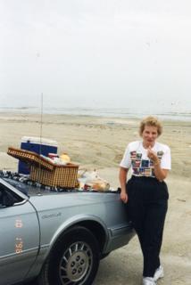
Then the part we won’t forget. We drove through the little village of Cameron and drove the car out onto Holly Beach right on the gulf shore. The sand was packed so hard it held up the car. We picked up shells, saw plovers and willets (birds) and then ate our picnic from the cooler off the hood of the car. It was a foggy day, like it can be along a gulf or ocean. It just looks overcast, but it is fog. We could see a couple of oil rigs through the fog.


We had our car parked only a short distance from the front door of a home on stilts. Most, (but not all) of the people who lived there were retirees or renters. (All the homes were on stilts). If you look at a map of Cameron on the Internet you will see Gayle Rd. The houses along Gayle face the beach. That’s how close they were to the water. We noticed a corner house that had big tables in their back yard with something coral on them, so we inquired of the 3 people who were working there what it was. They had a home business of putting out shrimp nets overnight and in the morning would bring in their haul, cook the shrimp and then dry them on drying screens. It takes 12 # of shrimp for one pound of dried shrimp. They offered us some to eat right off the screen, which we did. They didn’t sell them commercially, but put them in Ziploc bags and sold them right in town each day ($12 a pound), where the locals used them in Cajun dishes, like Jambalaya.


We drove west on #27 to Sabine Wildlife Refuge. Saw an occasional alligator, cormorants and purple gallinvule birds. Tried to walk the trails into the marshland, but the mosquitoes and flies were so bad we had to turn back. The humidity was heavy and later on it poured rain. We went to Lake Charles, but didn’t care for the town, so drove back east for the night.
We heard a lot about the hurricane hitting Beaumont, TX, but it actually came ashore between Cameron and Sabine Pass. Tonight the news showed an aerial view of Holly Beach and the town of Cameron. Everything was demolished, but fortunately they think everyone there evacuated. We always wanted to go back there. It makes us feel sad, because we had always felt a little bit of attachment there. Where have all those birds gone? To Arkansas, Texas, or further north?


No comments:
Post a Comment